Types of weather uncertainty
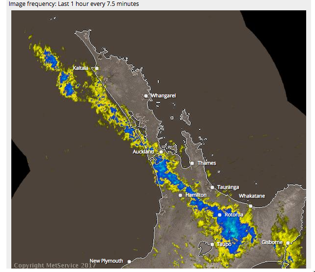
From the MetService rain radar

If the band of rain were moving north-east, small uncertainties in its motion and orientation would mean that you’d know there would be half an hour of rain in Auckland, but not exactly when.
If it were moving south-east (as it is), small uncertainties in the motion and orientation mean that you know it will rain for a long time somewhere, but not exactly where.
One way to communicate the difference between these two predictions would be to show a set of possible realisations of rainfall. For NW movement, you’d get a set of curves each with a single hump but at different times. For SW movement you’d get a much wider range of curves, where some showed no rain and others showed half a day or all day. I don’t know enough about ensemble forecasting to be sure, but I think this would be feasible
In principle, the common ‘patchy torrential downpours’ Spring rain pattern would show as rain curves each with different short periods of rain. I don’t think the technology is up to that using genuine predictions, but it might be possible to predict that we’re going to get that sort of weather and simulate the ensemble curves.
Current forecast summaries are mostly (except for hurricane paths) about averages: the probability of rain, the expected amount, the worst-case amount. As technology progresses we will increasingly be able to do better than averages.
Thomas Lumley (@tslumley) is Professor of Biostatistics at the University of Auckland. His research interests include semiparametric models, survey sampling, statistical computing, foundations of statistics, and whatever methodological problems his medical collaborators come up with. He also blogs at Biased and Inefficient See all posts by Thomas Lumley »
a former weather-dude friend of mine comments:
“*Very* rarely do you anticipate a band of rain like this moving, say, northwest and it actually moves southwest. That setup is completely different from the ‘patchy torrential downpours’ pattern he mentions in the following paragraph, which is more difficult to exactly predict, hence the use of a more probabilistic forecast. In that sort of regime and at that time scale, it’s an atmospheric modelling problem, not a stats problem.”
7 years ago
Yes, that’s not at all what I meant.
What I meant was what I said: when you know it’s moving southwest, you know there will be a lot of uncertainty in rain totals; when you know it’s moving northwest, you know there will be little uncertainty in rain totals but uncertainty in timing. That’s why I think standard forecast ensembles might be helpful in the long-narrow-band case but not in the patchy case.
7 years ago